
This page last revised 14 October 2008 -- S.M.Gon III
Introduction
Ecoregion
Conservation Targets
Viability
Goals
Portfolio
TNC Action Sites
Threats
Strategies
Acknowledgements
▫
Tables
Maps & Figures
CPT Database
Appendices
Glossary
Sources
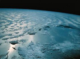
 Some of the world's wettest regions lie in the ecoregion's montane systems.
Portfolio of Sites
Conservation Areas
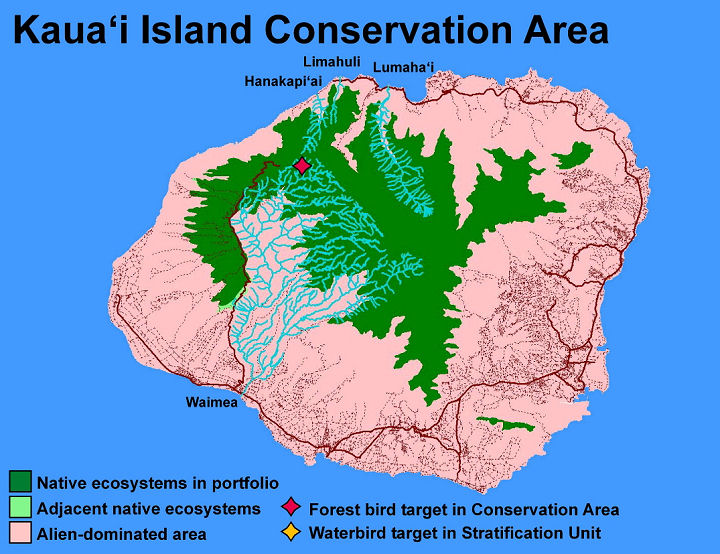
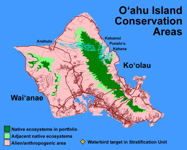
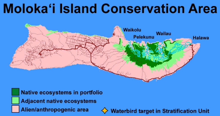
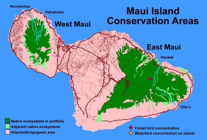
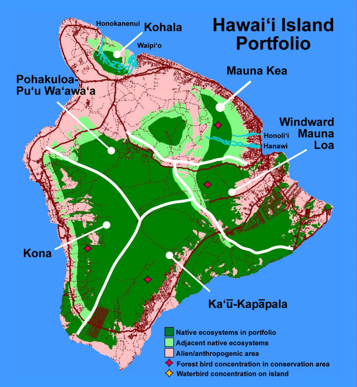
Following the portfolio assembly rules described in the Goalssection of this assessment, a series of ecological system, naturalcommunity, and species concentration targets wereselected, comprising the portfolio of conservation areas for theHawaiian High Islands Ecoregion. The geospatial representation at thearchipelago scale is shown in the map below and available at higher resolutionamong the Maps & Figures.
Theselected conservation areas, which represent the primary arena forTNC's ecoregional efforts, occur on all of the main islands exceptfor Ni‘ihau, Kaho‘olawe, and Lāna‘i. While the ForestBird Concentrations for each Stratification Unit typically overlapstrongly with montane mesic and wet ecological systems of theecoregion's conservation areas, the Waterbird Concentrations tend tooccupy alien-dominated coastal and lowland wetlands outside of the viable ecological system areas.
| PORTFOLIO OF CONSERVATION AREAS HAWAIIAN HIGH ISLANDS ECOREGION Kaua‘i Stratification Unit Kaua‘i Island Kaua‘i Conservation Area Kaua‘i Waterbird Conservation Area Kaua‘i Forest Bird Conservation Area O‘ahu Stratification Unit O‘ahu Island Wai‘anae Conservation Area Ko‘olau Conservation Area O‘ahu Waterbird Conservation Area Maui Nui Stratification Unit Moloka‘i Island East Moloka‘i Conservation Area Maui Island Maui Nui Waterbird Conservation Area East Maui Forest Bird Conservation Area East Maui Conservation Area West Maui Conservation Area Hawai‘i Stratification Unit Hawai‘i Island Hawai‘i Waterbird Conservation Area Hawai‘i Forest Bird Conservation Area Kohala Conservation Area Mauna Kea Conservation Area Windward Mauna Loa Conservation Area Ka‘ū - Kapāpala Conservation Area Kona Conservation Area Pōhakuloa - Pu‘u Wa‘awa‘a Conservation Area |

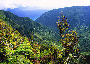
Native-dominated landscape, East Moloka'i Conservation Area
Conservation significance
The portfolio of conservation areas selected comprise the largest and most viable set of areas for establishing effective conservation(legal protection + abatement of critical threats, and maintenance of ecological processessupporting native biodiversity). They reflect the highest priorityareas for the work of The Nature Conservancy, focused on maintaininghigh-viability native ecological systems and the thousands of species withinthem. However, this is not intended to deter or discouragework outside of the portfolio. Important partner-led complementary conservationaction is needed in other areas, particularly for rare, threatened and endangered species.Elements of biological diversity, especially at the species level,occur in regions no longer dominated by native natural communities.These populations require specific management, includingspecies-focused threat abatement and habitat restoration. For example,the restoration work on the Island of Kaho‘olawe by the Kaho‘olawe Island Reserve Commission and its partners isessential for the recovery of that island's native biologicaldiversity. Additionally, our federal conservation partners are mandatedto recover 300+ threatened and endangeredspecies endemic to Hawai‘i. The Nature Conservancy looks topartners with specific mandates for species management or wholesale ecosystem restoration to lead in thoseessential areas.
Setting priorites
Whilethe selection of a portfolio of conservation areas is one way toestablish geospatial priorities for conservation work, the long-termnature of ecoregional conservation also allows us to define highestpriority areas, via assessment of conservation value, threats, and enabling factors. This process is discussed in the next section defining TNC Action Sites.

coastal assessment - add a mapping of coastal targets, and discussionof the selection of target subsets to reflect coastal portfolio.